Planning your next backcountry adventure isn’t as simple as picking a trail and packing a bag anymore. Weather patterns are shifting, trail conditions are less predictable, and outdoor enthusiasts are increasingly searching for reliable insights about the climate impact on hiking seasons. If you’re wondering how changing conditions affect trail access, safety, and timing, this article is built for you.
We break down what’s happening on the ground—how snowmelt timing is shifting, why wildfire seasons are extending, and what that means for your favorite routes. You’ll learn how to adjust your gear choices, trip planning strategies, and navigation tactics to stay safe and make the most of every outing.
Our insights are grounded in field-tested experience, current environmental data, and real-world backcountry observations. Whether you’re a seasoned trekker or preparing for your first extended hike, this guide will help you adapt confidently to changing outdoor conditions.
Beyond the Thermometer: Understanding El Niño and La Niña
El Niño and La Niña are phases of the El Niño–Southern Oscillation (ENSO), a climate pattern driven by shifts in Pacific Ocean surface temperatures. In simple terms: when the central and eastern Pacific waters warm up more than average, that’s El Niño; when they cool down more than average, that’s La Niña (NOAA, 2023). These temperature swings alter wind patterns and jet streams, creating global ripple effects that hikers feel months later.
El Niño typically brings:
- Wetter, cooler winters to the southern U.S., sometimes extending desert hiking seasons
- Warmer, drier conditions in the Pacific Northwest, leading to earlier snowmelt and elevated wildfire risk
La Niña often flips the script:
- Drought in the Southwest, shortening water-dependent trail seasons
- Heavy snowpack in the northern Rockies and PNW, delaying access to high-alpine routes
This climate impact on hiking seasons can shape everything from permit timing to gear choices. Still, forecasts aren’t crystal balls (even meteorologists admit that). Seasonal outlooks show probabilities, not promises.
For trip planning, check NOAA’s Climate Prediction Center ENSO updates. Pro tip: review forecasts three to six months ahead and recheck monthly for trend shifts. Think of it less like checking tomorrow’s weather and more like reading the long game—nature’s version of a slow-burn plot twist.
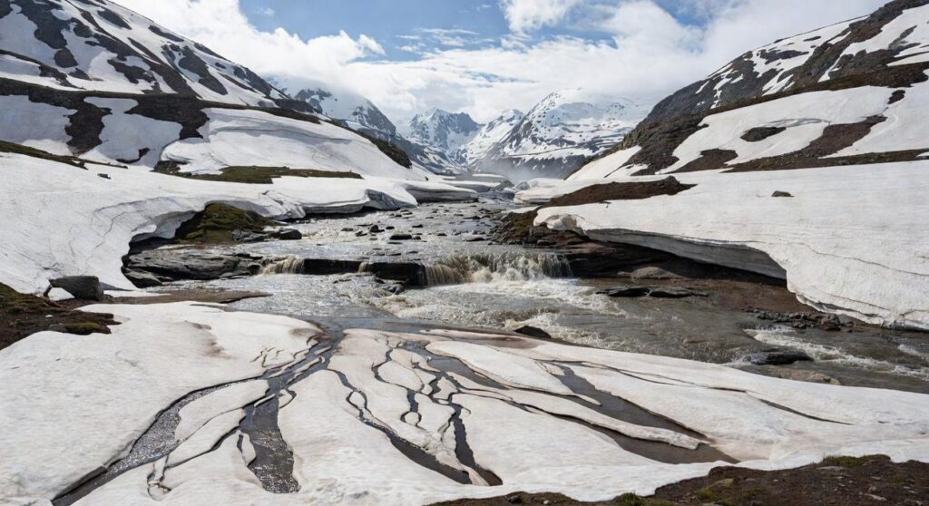
The Mountain Gatekeeper: Snowpack and Spring Melt Dynamics
Snowpack depth is the single most important factor in determining when high-altitude hiking season truly begins. Snowpack refers to the accumulated layers of snow that build up over winter; its density and depth dictate how long trails stay buried. In 2017, for example, California’s Sierra Nevada saw snowpack levels exceeding 150% of average (California Department of Water Resources), pushing safe John Muir Trail access well into July.
Low vs. High Snowpack Years
Low Snowpack Years
When snowpack measures below median—say 60% of normal by April 1—trails can open weeks early. Colorado’s high passes sometimes become passable by late June instead of late July. Sounds great, right? Not so fast. Less lingering snow means reduced late-summer water sources and a longer wildfire window. By August 2021, several Western states experienced severe fire conditions tied to early melt and dry fuels (NOAA). Early access can also mask fragile trail conditions (mud season is REAL).
High Snowpack Years
In contrast, above-average years compress the hiking season. North-facing slopes and shaded passes hold ice well into midsummer. River crossings swell with meltwater, increasing risk; the Pacific Crest Trail saw multiple hazardous crossings during the heavy runoff of 2019. The upside? Meadows stay greener longer, and alpine wildflowers explode in late July.
This variability underscores the climate impact on hiking seasons, where long-term warming trends shift melt timing earlier across much of the West (EPA).
How to Track It
Use the SNOTEL network (NRCS) to monitor Snow Water Equivalent (SWE)—the amount of water contained within the snowpack. Compare current SWE to 30-year medians. If SWE drops rapidly in May, expect earlier trailhead melt-out within weeks. Pro tip: check historical melt-out dates alongside current trends before locking in permits.
For policy shifts affecting trail access, review new conservation policies every outdoor enthusiast should know.
The Smoky Season: How Wildfires Are Redrawing the Hiking Map
For many hikers, “fire season” used to be background noise. Now, it’s a primary factor when planning summer and fall trips—especially across the western U.S. and Canada. The climate impact on hiking seasons has shifted peak adventure windows, and understanding that shift gives you a real advantage: better air, clearer views, and safer miles on the trail.
Impact on Timing
Traditionally, August and September were prime backpacking months. However, those weeks now often bring heavy smoke and active burns. As a result, savvy hikers are moving big objectives to June and July. Earlier trips can mean snow patches at higher elevations, but they also offer cleaner air and fewer last-minute cancellations (a fair trade for carrying microspikes).
Health and Safety
Wildfire smoke contains fine particulate matter (PM2.5) that can irritate lungs and worsen asthma, according to the EPA. Poor visibility also complicates navigation, increasing the risk of wrong turns. Choosing low-AQI days protects your lungs and sharpens your route-finding.
Planning Tools
Before heading out, check AirNow for official AQI forecasts, PurpleAir for hyper-local sensor data, and InciWeb for active fire updates. Pro tip: set AQI alerts the week before your trip so you can pivot early. The payoff? Fewer surprises—and more summit photos without a smoky haze.
Navigating Regional Patterns: Monsoons and Hurricanes
I once started up a peak in Arizona under bluebird skies, only to watch thunderheads stack up like something out of a disaster movie by 11 a.m. That’s the Southwest Monsoon (July–September) in action. In Arizona, Colorado, and New Mexico, intense afternoon thunderstorms can trigger dangerous flash floods—especially in narrow canyons. Plan early summit bids and aim to be below treeline by noon (seriously, set the 4:30 a.m. alarm).
Meanwhile, Atlantic Hurricane Season (June–November) reshapes trails across the Southeast. Even distant storms can hammer the Appalachian Trail in North Carolina and Virginia, causing:
- Trail washouts
- Sudden creek flooding
- Blowdowns blocking miles of tread
Some hikers argue forecasts make worries overblown. However, hyper-local systems shift fast, and the climate impact on hiking seasons is becoming harder to ignore (NOAA). Build buffer days into itineraries, check forecasts frequently, and expect plans to change. Flexibility isn’t optional—it’s survival.
Make Your Next Adventure Smarter and Safer
You set out to understand how shifting weather patterns are reshaping your time on the trail. Now you can clearly see how climate impact on hiking seasons is altering trail conditions, shortening peak windows, and increasing unexpected risks for outdoor explorers.
Longer heatwaves, unpredictable storms, wildfire smoke, and unstable terrain aren’t minor inconveniences—they directly affect your safety, gear choices, and route planning. Ignoring these changes can turn a dream hike into a dangerous situation.
The good news? You don’t have to navigate these challenges alone. With the right backcountry knowledge, updated seasonal insights, and proven survival strategies, you can confidently plan trips that match today’s evolving conditions.
If you’re serious about hiking smarter, protecting yourself from unpredictable climate shifts, and discovering trails that are still worth the journey, start exploring our latest field-tested guides and trail insights today. Join thousands of outdoor enthusiasts who rely on our expert resources to stay prepared, adaptable, and adventure-ready. Your next safe, unforgettable hike starts now.